
How We Lost Our Drone at Cotopaxi | the Tale of Tío Lobo
Flying a drone at Cotopaxi promises epic aerial shots and dramatic video sequences. Just don’t throw caution to the wind at this sacred volcano. Provoke the drone gods, and prepare to answer to the supreme authority of their earthly avatar.
As a child, the feeling of shame that comes from the disapproving reprimand of an adult is enough to shrink us to nothing. In an instant, all youthful innocence is lost. It’s that moment we know we’ve been caught — and we’re truly guilty.
The finger shake. The cold, stone-faced glare. Physical manifestations that sometimes speak louder than words ever could.
Then, there are the words themselves, which come in many forms. The furious tirade. A firm, disciplinarian lecture. The low, guttural, teeth-grimacing grumble.
Caught red-handed? How ‘bout a healthy dose of “what do you think you’re doing?”
Futile effort to plead false innocence? “Let me guess — it wasn’t your fault.”
And is anything more frustrating than the laziest catch-all of them all: “because I said so”…?
Surely, we’ve all been on the receiving end of these verbal daggers, at one time or another. However, none compare to the ultimate secret weapon of shame-inducing guilt. Yes, those of us that have heard them, know there’s no greater assault on the developing juvenile ego than those 6 painful words:
“I’m not upset; I’m just disappointed.”
This very particular sequence of words does far more than communicate the simple fact that you’re in trouble. It possesses a unique power to teach lessons long after the incident in question has come and gone.
Oh, how we yearned to grow older, so we could pull our own verbal arrows from the quiver of authority…
Caution: (fragile) adult ego at play
Having grown and matured to adulthood – and having mastered all of life’s lessons along the way – we no longer find ourselves on the receiving end of such screwup-inspired scolding. Instead, we draw from past experience to impart wisdom upon younger generations. We unsheathe these sharp, cutting blades only when the circumstances truly call them to battle. And we wield them slowly, clearly, and with purpose, to ensure the desired effect is achieved.
Yet sometimes, as adults, we forget that a driver’s license and a bank account don’t exonerate us from playing by the rules, as children must. We conveniently overlook the fact that mere access alone does not – by default – grant us the right or privilege to do something.
Yes, sometimes, as adults – despite our better judgment – we find it too easy to regress to our former childlike selves, tempting fate and pushing boundaries that we know deep down shouldn’t be crossed. And whether it’s through entitlement, arrogance, or sheer negligence, we’re often fully aware of what we’re doing when we color outside these lines.
While the adult ego is fully-formed (some might argue, overinflated), the right words – the perfect sequence of carefully-selected words – can shatter it in an instant.
Having grown taller since childhood, our adult ego has only further to fall.
***
The Neck of the Moon
From the makeshift mountainside parking lot, the neck of the moon looms dauntingly above us. Sporadic cloud cover breezes past, intermittently obscuring the rocky, snow-capped volcano from view. But when the clouds break, she reappears, with an imposing presence that is humbling.
Nestled within a stretch of the Ecuadorian Andes known as Volcano Avenue, Cotopaxi is an awe-inspiring sight to behold. She’s the second tallest volcano in Ecuador; #34 in the world. Measuring up just a narrow 2 meters / 6 feet shy of Cotopaxi is #35 on the list: Tanzania’s revered Mount Kilimanjaro. But outside of South America, no volcano stands taller than Cotopaxi.
The name Cotopaxi is Quechua for “neck of the moon” – in reference to her crescent-shaped crater. To most tourists, Cotopaxi and her siblings – Chimborazo, Quilotoa, Tungurahua and others – are photographic destinations. But to the Quechua people that call this area home, these geothermal phenomena are more than just surrounding landmarks. They are powerful entities that have impacted daily life for generations, with an unpredictable volatility that holds millions of lives in their hands.
Centuries ago, Andean locals worshiped Cotopaxi as a “rain sender;” a heavenly body that ensured the land’s fertility. They also deified her as a sacred mountain, holding firm to the belief that gods dwelled within her summit.
But this sacred mountain isn’t all life-giving. Cotopaxi is one of Ecuador’s most active volcanos, and while she may facilitate creation, she can just as readily bring about destruction. On Easter Sunday 1996, 13 people lost their lives on her slopes, not due to eruption, but rather by avalanche that resulted from an earthquake. Cotopaxi last erupted in 2015, sending blankets of ash all the way to Ecuador’s Pacific coast, 465 km (290 miles) away.
Perhaps it’s the extreme duality associated with her existence — that of fire and ice — which adds to her mystique and attracts thousands of mountaineers & hikers to summit her snow-capped peak every year.
A face covered in snow, with billions of gallons of molten lava below.
Apparently, inherent danger is part of the thrill.
***
Ascent to sanctuary
Refugio José Rivas serves as base camp for those who seek to summit Cotopaxi. After lacing up our boots in the parking lot, we trudged up the 100 meter incline to Refugio at a snail’s pace of 40 minutes. The altitude is no joke, and even less so for those not acclimated.
When we finally reached Refugio Base Camp, we rejoiced, snapped photos, and enjoyed a well-deserved round of hot chocolate and cold empanadas, courtesy of Oscar, a local mountaineer who has summited the volcano upwards of 30 times.


Refugio houses 76 beds, which provide a resting place for hikers and guides prior to making their ascent. For safety reasons, the guide-to-hiker ratio is a strict 1:2.
The trek begins shortly after midnight and lasts between six and seven hours, on average. Depending on pace, you can expect to summit just before sunrise.
On a clear day, you may even catch a glimpse of Colombia from the top.

We enjoyed our time with Oscar, and from what we could tell, the feeling was mutual. Some days – Oscar freely admitted – he doesn’t get a lot of company.
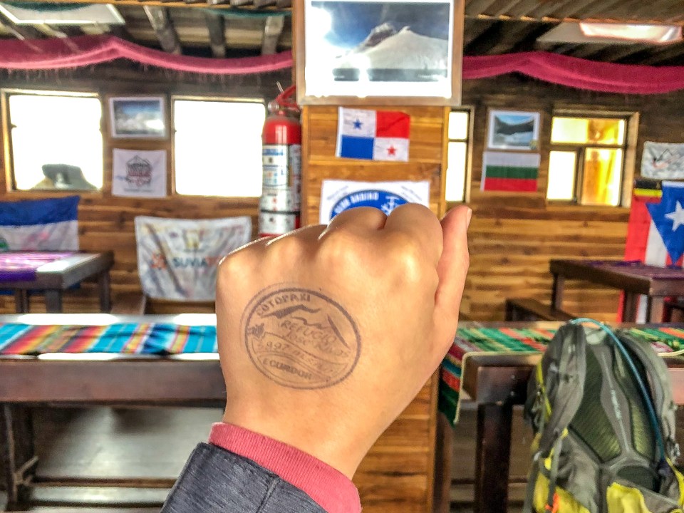
After a second round of hot chocolate, he stamped our hands and notebooks with the official Cotopaxi seal (he’ll stamp your passport if you have it with you). Then, we signed the wall (also customary) and bid farewell to our new friend.
But just before our descent – with Oscar’s blessing – we also launched our drone.
***
How we lost our drone at Cotopaxi
Cotopaxi drone flight #1: Refugio Base Camp
Knowing that the altitude could present issues for the expected performance of the aircraft’s LiPo (lithium polymer) batteries, we decided to take Androne 3000 for a spin.
Also, having no idea what sort of implications existed as far as connectivity between the aircraft and the remote controller – yet knowing full well that if we DID encounter an issue mid-flight (battery, signal, or otherwise), we were essentially screwed – we decided to fly our drone at Cotopaxi.
Correction: I decided to fly our drone at Cotopaxi. D was not in love with the idea.
Fortunately, the flight went off without incident. Plus, it yielded some cool shots of Refugio – the mountain’s only sanctuary – set against the harsh, inhospitable landscape that surrounds it.

***
Cotopaxi drone flight #2: Refugio Parking Lot
Now back at the car preparing to head out, the skies cleared yet again. Still floating on an undeserving cloud of confidence from the first flight, I convinced myself that this opportunity was far too good to pass up. Another chance to capture epic aerial shots and dramatic video sequences, highlighting the rugged beauty of Cotopaxi.
At the moment of launch, a man who had been watching me from a nearby car, approached.
One could only assume that Tío Lobo (“Uncle Wolf”) was born on this mountain. Below the brim of a cap pulled down low upon his forehead – and above the long, scraggly gray beard that descended well below his neckline – his face displayed leathery, weather-beaten skin. His cheeks were tattooed with mild wrinkles, deep cracks and permanent scars. Sunken deep in their sockets, a pair of almost colorless yet soulful eyes depicted a man who has stories to tell; a man who has seen some shit.
A wry smile and polite chuckle are his immediate responses when we tell him about our 40 minute ascent to Refugio. He makes the same trip in 15 minutes – with either a propane tank or backpack full of supplies for the base camp – as many as 10 times a day. His thin frame had likely never stepped foot inside a gym, yet it was glaringly obvious that this man wasn’t pulling any punches.
A (very) fair warning
Tío Lobo expressed a genuine interest in the drone. Now mid-flight, I show him the iPhone screen, which offers a visual of what the camera is capturing at that moment. At first, his eyes light up with fascination.
Then, his tune changes slightly, and he voices concern:
- birds that could be injured if they were to mistake the drone for prey, and attack
- flora & fauna that would be affected if it were to crash
- other animals it would impact, if they were to find it on the ground

Calmly, I reassure him (using my best mediocre Spanish) that we exercise extreme caution when flying; that we never fly it out of visual line of sight; and that we always land it immediately if we see birds circling in the area.
Our chat is friendly. Although, it ends with a final, ominous word of warning from Tío Lobo.
Cuidate.
Flight 2 delivers some of the best footage we’ve captured to date. We land the drone, bid farewell to our newest friend, pack up the car, and exit the parking lot.

***
Cotopaxi drone flight #3: down the mountain
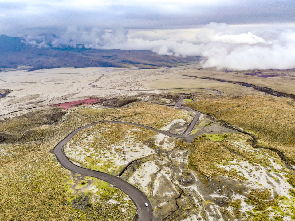
The surrounding terrain is dry, barren, beautiful. Scattered alpine flora emerge from patches of red earth. Wild horses roam freely. A few alpacas graze off in the distance. Behind us, the majesty of Cotopaxi. In front of us, the glasslike surface of Limpiopungo Lagoon.


This wide open space — completely free of overhead hazards such as trees and power lines — coupled with a terrain that demands slow, cautious driving, offered another perfect opportunity. No more than five minutes after leaving the parking lot, I make my pitch for our third flight of the day.
D is comfortable with our surroundings. She gives the green light, and suggests we capture some ActiveTrack footage. We install our third and final fresh battery, and go through the pre-flight setup routine, yet again.
Drone note: ActiveTrack is a mode that allows the drone to follow a defined subject (for example: a person or a car) at a fixed distance, while maintaining camera focus on said subject, even while it’s in motion.
D launches Androne 3000 high into the air, selects our vehicle as its tracking target, and I start driving. From the backseat with the window cracked halfway, D monitors the drone – alternating between the in-hand phone controller and visual line of sight – as it obediently follows us down the meandering snakelike road.


***
Cotopaxi drone flight #4: from dusk, till gone
OK, now I’m satisfied. Let’s hit the highway home.
But I’ve spoken too soon, and my adult ego abruptly emerges to silence my inner voice.
This forest…the sky…these colors! We’ve gotta get Androne up one more time to capture this scene.
As quickly and dramatically as the landscape has changed, so too have my discipline and good judgment gone by the wayside.
This time, I act without first consulting D. After all, we only have a few precious minutes of daylight left.
I pull over, and for one last time, launch the drone. I hand the controller to D, and get back behind the wheel.

Throwing caution to the wind: how we lost our drone at Cotopaxi National Park
Despite today’s past operational sins having been forgiven (tempting fate with the batteries…and the signal…at untested altitude), my fatal flaws with this flight were many.
What finally provoked the drone gods to unleash their wrath upon us? Here’s a re-cap of the perfect storm that ensued while flying our drone at Cotopaxi National Park, for the last time:
1. Remaining in ActiveTrack mode
Again, the landscape has changed. The rocky, pothole-filled pathways of before, which demanded painfully slow speeds, have turned to paved 2-lane roads with frequent sharp curves. We’re still within the boundaries of the national park, and there are no other cars around, but I’m driving at (the much faster) park speed limit of 35 km/h (22 mph).
At this speed — and around these curves — it’s next to impossible for a recreational drone like ours to remain locked on to its tracking target (our vehicle) while in ActiveTrack mode.
2. Obstacle interference
In contrast with the wide open space from flight #3, we’re now driving through a dense forest of tall pine trees. I account for this by positioning the drone “safely” high above the tree line, but with the frequency and severity of the road’s curves, we quickly lose line of sight with the drone. A couple more turns, and we lose signal as well.
Drone note: while it’s always advised (or legally required) to maintain visual line of sight for both safety and signal connectivity reasons, this doesn’t always happen in practice. Often, it’s without consequence. Fly your drone a mile or more away from you, and even with line of sight, you may lose signal. But at a close distance (for example: the other side of your house, but only 20 feet away from you), you’ll likely maintain connection with both the flight system and vision system, despite physical obstacles. Admittedly, semantics.
3. Not changing the battery
It’s our standard operating procedure to always replace the battery for a new flight, at anything less than 70-80%. Well, we had installed our third and final fully-charged battery on flight #3, and ran it down about halfway. Unfortunately, with no more fresh batteries, I allowed greed & arrogance to overshadow reason & protocol. Just a few more photos…EASY. This last piece of the puzzle sealed our fate.
Incidentally, it turns out that drones cannot operate on human ego alone.
We did eventually regain signal from the aircraft, which provided a fleeting moment of relief. Although, the battery level indicator has dipped below 20%. At this point, I’ve pulled the car over, switched from ActiveTrack back to normal flight mode, and am attempting to manually navigate the drone back home using on-screen GPS. Around 15%, I lose connectivity again. This time, both GPS and visual signal are gone.
A moment of panic. The flicker of the screen on and off as the drone and controller attempt to communicate with each other.
Between screen flickers, I see the Return to Home icon flash. Now, this is actually a GOOD sign as this feature will manually override whatever I’m trying to do, and attempt to bring the drone back “home” to its launch point. Unfortunately, this presents a new challenge: we’re a kilometer (or more) from where we launched, and it’s getting darker by the second.
Does anyone remember where “home” is?
Will the drone even make it?
It doesn’t matter. It’s too late.
The screen flashes 11%.
Then, it’s all black.

***
Searching for our drone at Cotopaxi National Park
We backtrack to a stretch of road that feels pretty close to home. Androne 3000 is definitely no longer airborne, but I’m able to pick up a GPS signal on the controller. We’re close. But if we’re following the GPS, we’ll have to venture into the woods.
D remains by the car. Brett, Kristen and I begin making our way into the thick forest, guided in part by the GPS arrow, and largely by desperation. Natural light from the sun is about half of what it was 10 minutes ago. We make it no more than 10 steps, then stop and turn at the sound of a vehicle approaching.
A recognizable pickup truck slows to a stop, and the driver side window rolls down.
TÍO LOBO?! ¿Qué tal? [what’s up?]
¿Qué hacen? [what are you guys doing?]
[bad Spanish] Man. Crazy…but…we were flying the drone down here and…we can’t find it. We’re just…
He slowly raises his hand to reveal a familiar-looking object through the truck’s window.
¿ESTE DRONE?
NO. ME. JODAS. [you’ve gotta be kidding me…sort of]
He hands the drone to D, and says nothing more. We quickly scramble to pull some cash together to thank him, and hand it over. He responds with a light nod and nonverbal look of disappointment.
Then, as suddenly as he appeared, our guardian angel was gone.
***
Words, as weapons
In the four minutes that elapsed since we officially lost signal, Androne 3000 had apparently returned to home and landed safely on a patch of paved asphalt—just moments before Tío Lobo drove past. And all of this, less than 45 minutes since we met him in the parking lot, and heard his ominous warning.
Still trying to make sense of it all, we soon arrive at the national park gate. At this point, it’s nearly 6:30pm. The ranger station is closed. Then, I realize: they have my driver’s license. I handed it to a ranger when we entered, as collateral exchange for a national park entry placard. As it was explained to us, this is how they keep track of visitors within the park. Standard operating procedure.
I pull into the parking lot, to assess our options. We’re supposed to be heading back to Quito right now, nearly 3 hours north. I’ll probably have to drive back here tomorrow to pick up my driver’s license.
Someone notices human silhouettes through the windows of a ranger office next to the public restrooms. I knock on the door, and am greeted by a park worker, who seems less than pleased with the intrusion. I explain the situation. He grabs a set of keys, walks me over to the guard station, and retrieves my driver’s license.
Don’t do this again.
Won’t happen again.
I’ve just about made it back to our car when I see another unamused face, staring back at me from the doorway of the ranger office. This one though, looks familiar. I approach him.
[bad Spanish] Tío Lobo, I just wanna say that I’m so sorry for what happened today…and we’ll be more careful next time…and…
Suddenly, our guardian angel is a figure of unquestionable authority. He raises a single finger – the index – and cuts me off.
YA TE DIJE.
[literal translation] I already told you.
[within context] I told you so.
***
Kids will be kids.
And they eventually learn to accept that when you act out of line, you may get busted.
So if we – as adults – choose to act like kids, do we not also deserve to be spoken to like children?
Though we may have graduated beyond the years of being grounded, sometimes we owe ourselves – and our fellow global playmates – a self-imposed timeout, to think about what we’ve done.
It was a long drive back to Quito that night. I had plenty of time to think about it.

Divine intervention?
Months later, D and I still debate whether this had been our craziest experience in Ecuador. But that evening, while driving home from that profound yet surreal series of encounters, we actually found ourselves asking: did that just happen?! Or was it all some sort of shamanic hallucination?
Is Tío Lobo a real person? Or an earthly embodiment of the ancient deities that were believed to have dwelled within Cotopaxi’s crater?
That it all went down on a sacred volcano known for being both a giver of life, and bringer of destruction? Well, whatever the truth is, we found relief in the fact that on this day, the mysterious mountain chose mercy.
As for Tío Lobo, perhaps it makes sense that he’s some sort of symbolic, all-seeing-all-knowing avatar, tasked with policing and protecting the mountain from those who break the rules; and re-setting boundaries for others that play a little too close to the edge.
He too had the power to both take away or give back, and we’re eternally grateful for his decision.
One thing’s certain: this lesson did not fall on deaf ears. We will certainly not need to be told again.
***
Reminders for flying a drone at Cotopaxi National Park (and life, in general):
- Know your operational capabilities and limitations.
- Operate/behave safely, responsibly, and within legal guidelines.
- Respect national park rules.
- Respect nature.
- Be a respectful citizen of the world.
- Finally, when you’re in someone else’s backyard, be prepared to play by their rules.


One Comment
Pingback: